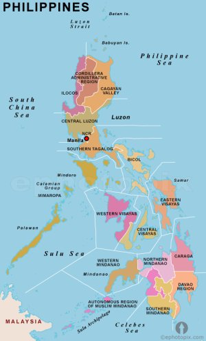
Map of the Philippines by Region and Political Map of the Philippines
As seen on a map of the Philippines by region, the country is an archipelago, which makes managing the political affairs challenging.
At the highest level, the country is divided into 3 main areas: Luzon, Visayas and Mindanao. These three areas are then further divided into 17 regions based on geography, culture, and language.
The 17 regions are then further divided into provinces, then districts, cities, towns, and finally the smallest political unit is a baranguay (neighborhood).
Let's look at a map of the Philippines by region and each region of the country, beginning at the northern area of Luzon Island and continue down to the southern end of Mindanao.
Cordillera Administrative Region (CAR)
Sitting at the northern tip of Luzon, it contains the provinces of Abra, Apayao, Benguet, Ifugao, Kalinga, Mountain Province and Baguio City (the regional center)
Ilocos Region (Region I)
Encompassing the northwestern area of Luzon, the region is composed of four provinces, namely: Ilocos Norte, Ilocos Sur, La Union and Pangasinan. Its regional center is San Fernando City, La Union.

Map of the Philippines by Region
Cagayan Valley (Region II)
Occupying the northeastern area of Luzon, it is composed of five provinces, namely: Batanes, Cagayan, Isabela, Nueva Vizcaya, and Quirino. It has three cities, with Cauayan City its regional center
Central Luzon (Region III)
In the center of Luzon, its provinces are: Aurora, Bataan, Bulacan, Nueva Ecija, Pampanga, Tarlac, and Zambales.
National Capital Region (NCR)
Consisting of Manila itself, and the cities of Caloocan, Las Piñas, Makati, Malabon, Mandaluyong, Marikina, Muntinlupa, Navotas, Pasay, Pasig, Parañaque, Quezon City, San Juan, Taguig, Valenzuela—and the municipality of Pateros.
Calabarzon (Region IV-A)
Cavite, Laguna, Batangas, Rizal, and Quezon are the regions, and Calamba City in Laguna is the regional capital.
MIMAROPA (Region IV-B)
Consisting of the regions Occidental Mindoro, Oriental Mindoro, Marinduque, Romblon and Palawan.
Bicol Region (Region V)
Residing here are 6 provinces, which are, Albay, Camarines Norte, Camarines Sur, Catanduanes, Masbate, and Sorsogon. Legazpi City is the regional political and administrative center.
Western Visayas (Region VI)
It consists of six provinces; Aklan, Antique, Negros Occidental, Capiz, Guimaras and Iloilo with Iloilo City being the regional center.
Central Visayas (Region VII)
Bohol, Cebu, Negros Oriental, and Siquijor exist in this region and Cebu City acts as the regional and cultural center.
Eastern Visayas (Region VIII)
Existing in this region are 6 provinces, Biliran, Eastern Samar, Leyte, Northern Samar, Samar and Southern Leyte. Tacloban City functions as the regional center, as seen on a map of the Philippines by region.
Zamboanga Peninsula (Region IX)
Contained in the region are 3 provinces, namely, Zamboanga del Norte, Zamboanga del Sur, and Zamboanga Sibugay. The regional center is Pagadian City.
Northern Mindanao (Region X)
Composed of Bukidnon, Camiguin, Lanao del Norte, Misamis Occidental, and Misamis Oriental, Cagayan de Oro City functions as the regional center.
Davao Region (Region XI)
Davao Region consists of four provinces, namely: Compostela Valley, Davao del Norte, Davao Oriental, and Davao del Sur. Its regional center is Davao City.
SOCCSKSARDEN (Region XII)
South Cotabato, Cotabato, Sultan Kudarat, Sarangani and General Santos City form the 4 provinces and the regional center is Koronadal City.
Caraga (Region XIII)
Found here are the 5 provinces of Agusan del Norte, Agusan del Sur, Dinagat Islands, Surigao del Norte and Surigao del Sur with Butuan City acting is the regional center.
Autonomous Region of Muslim Mindanao (ARMM)
Basilan, Lanao del Sur, Maguindanao, Sulu and Tawi-Tawi, and the Islamic City of Marawi form the provinces as shown on a map of the Philippines by region, with the regional capital being at Cotabato City.


